 (106 KB JPG)
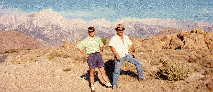
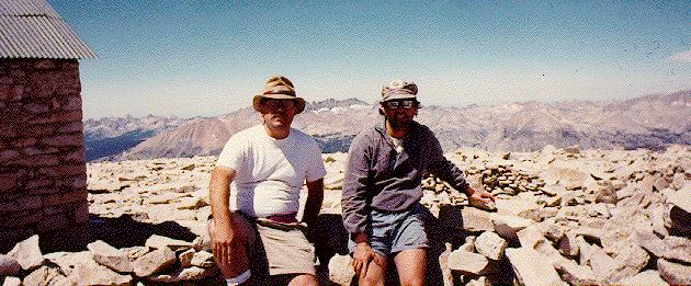
Dave (in the hat) and Todd by the road side. Whitney is the tallest peak between their heads
Also, here's are lists of books you can buy about Mount Whitney or The Sierra
I left work at about 6:15 and picked up Dave and Todd at Todd's house. We stopped briefly at Target to pick up a Panoramic Camera, then we were on the road. Traffic was fairly heavy getting out of the LA Metro area, but once we were on 395, it thinned out quite a bit. The drive along highway 395 is basically deserted, so there's not a lot of light. During the whole drive there was a lightning storm which lit up the Owens Valley and hinted to us that it might rain on our hike. Nevertheless, it wasn't raining now and our spirits were high.
We got to the Mt. Whitney Ranger Station at about midnight and we were the first people there. We set out our sleeping bags and tried to get some sleep. Unfortunately, several factors conspired to keep us from sleeping. It was 75 to 80 degrees out the whole night, the mosquitos were numerous, there was a cricket who had better amplification than the last Stones tour, and of course there was the fact that the area in front of the ranger station is mostly cement. Worst of all, it's located right on 395 at the edge of town (the town being Lone Pine). This meant that every few minutes a truck would come into town downshifting uproariously as they passed our spot. Needless to say, we didn't get much sleep.
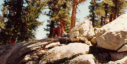
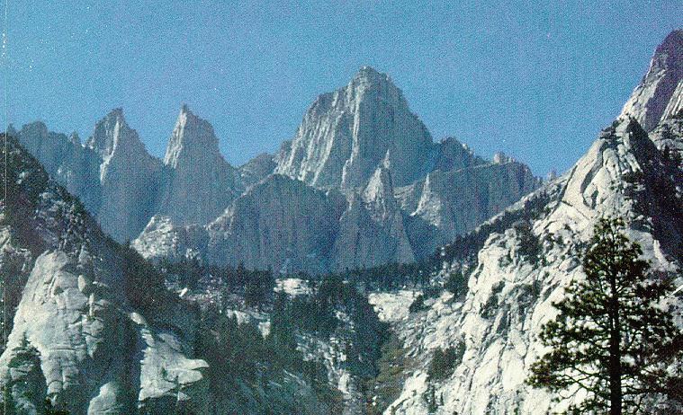
At about 2 or 3 AM, some other people started showing up at the ranger station. By dawn, there were about twenty of us, all waiting for those standby spots. There was a night pickup-box for people who wanted to pick up their permits before the ranger station opened, and there were permits for 18 people still in the box, so it looked like most (if not all) of us would get our permits. At about 6 we took turns going to a local diner (PJ's) for breakfast, knowing it would be our last non-dehydrated food for a couple of days. About the time the last of us got back, a red-headed ranger rode up on a bicycle, and went around to the back of the ranger station. A few minutes later, she came out and said that there was one cancellation for a group of 3. Since we were first in line, this meant we'd get an early start. We made a quick pit-stop to buy a spoon for Dave and headed for the mountain. I made Todd stop alongside the road so I could get a picture before we started
(106 KB JPG)
Dave (in the hat) and Todd by the road side. Whitney is the tallest
peak between their heads
Though we got to the trailhead early, it took us a while to get our stuff ready to go. Todd and Dave both had rental packs, and both had small problems with them. Dave's wasn't adjusted for his height, and Todd's had a broken strap on it, so we took some time to solve these as well as possible and then got on our way. It looked like it was going to be warm for the hike, so we were all happy to leave a couple of pounds of extra clothes behind in the car. On past hikes, Todd had always been the power hiker, nearly driving everyone to exhaustion, but not so on this trip. Whether he was out of shape or just not ready for the altitude, he was lagging behind almost right from the start. Dave and I had done a training hike to Mount Baldy the week before, so we were ready to go, but the scenery was so beautiful that we didn't mind going a bit slower for Todd's sake.
 (117 KB JPG)
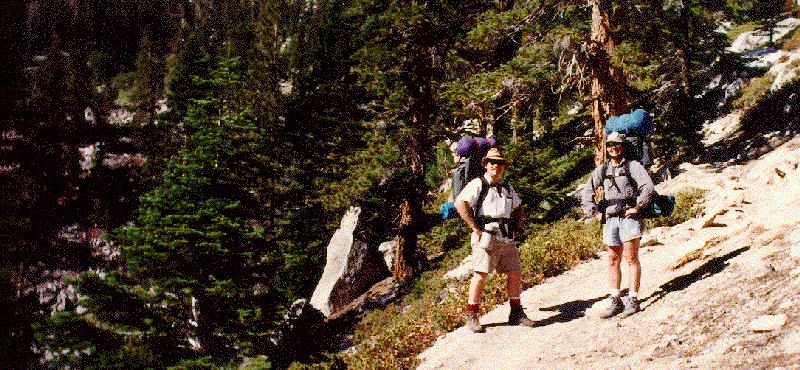
Dave and I on the trail
My new boots were comfortable, but started to rub a bit on my heels, so we stopped about 2 miles along so I could put some moleskin on. Todd's pack was screwed up worse than he though, so by the time we got to Lone Pine Lake, he had a sore shoulder from where he tied a knot to fix the broken strap. We stopped for snacks, and to replenish water from the lake. We had someone take a picture of all 3 of us standing in front of the lake, but he turned out to be no Ansel Adams. Here's this beautiful mountain lake nestled in the rocky slope, and this genius takes a picture of 20 feet of rock in front of us and missed the whole damn lake.
 (30 KB JPG)
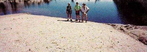
Dave, Todd, and I at Lone Pine Lake.
At Lone Pine Lake, the mosquitos are thick as the smog in L.A. is often wont to be, so we sloshed on some jungle juice to keep them at bay for a while. I was getting a little antsy, as it was already 11:15 and we had barely started the hike (2 1/2 miles out of 6, but the easiest ones). Finally we forged ahead toward Mirror Lake and lunch.
 (52 KB JPG)
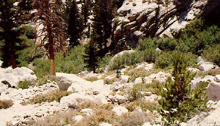
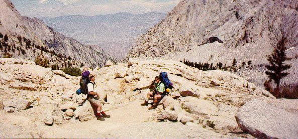
Todd (about the middle of the picture) ascending the slope above
Lone Pine Lake
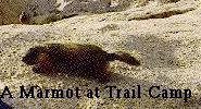
Todd stopped to rest at Outpost Camp, but Dave and I went ahead and told him we'd wait for him at Mirror Lake. We got to Mirror Lake about lunch time, and Todd arrived about 10 minutes after we did. As I opened my pack, some gorp spilled out and almost immediately a marmot poked his head out from under a nearby rock. I quickly grabbed my camera, hoping he would stay in sight while I took the picture. To my amusement, he came the rest of the way out of his hole and posed for me.
 (41 KB JPG)
A hungry marmot at Mirror Lake.
We dubbed the marmot "Marvin" and shared some of our lunch with him. He was actually quite brave and came within a few feet of us to get some food. Our generosity didn't go unobserved, and soon we had a whole menagerie of mendicant critters scurrying around and begging for food. They were pretty bold, so we had to keep an eye on our packs or we'd have some stow aways for the rest of the hike.
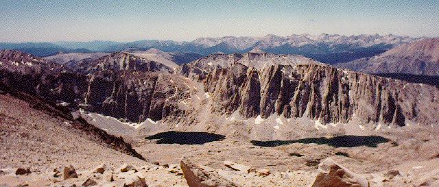
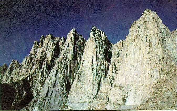
They don't allow camping at Mirror Lake because it developed a "montane slum", whatever that is. Too bad, cause it's a nice little spot with lots of shade and trout leapin' in the lake. I thought we got our first view (from the trail) of Whitney, just peeking over a notch between Thor peak and Wotan's Throne. I later found out that it was a couple of the needles which are located just south of Whitney. Whitney is obscured by the pinnacle ridge on the right of the picture. Thor peak is on the far right.
 (44 KB JPG)
The needles viewed from Mirror Lake
It's good that we got a nice long rest at Mirror Lake, because right after that the trail became steeper and rockier. We passed above the timberline at about 2, so there was very little shade and it was hot out.
 (62 KB JPG)
Dave and Todd resting just above the timber line.
Somewhere in this part of the ascent Todd twisted his knee, so Dave and I stopped to put an Ace bandage on it. After a short break, I went on ahead, as I was getting more worn out from taking off and putting on my pack than just continuing. About a mile after I left them, I came to Trailside Meadow, so I laid down for a few minutes to rest, hoping they would catch up. After about a half an hour, they still hadn't shown up, so I pressed on for the last mile to Trail Camp. I was worn out, overheated, and I had a headache from the altitude, so when I saw the first tents set up by the trail, I pitched my tent and laid down inside to try to get rid of my headache. No such luck.
The sun was still pretty hot out, so even with the windows open it was about 85 degrees in the tent, and not all that dark. On top of that, I'd set up the tent pretty quickly and sloppily, so it's loose edges were flapping in the breeze pretty loudly. As was the case the night before, I didn't get any sleep. Needless to say my headache didn't go away. Furthermore, since my tent was new, Dave and Todd didn't know it by sight. They hiked right by me and on to a campsite further along in Trail Camp. After huddling miserably in my tent for a while, I decided that a trip to the "solar toilet" might improve my condition, so I started up the hill to the main part of camp.
I ran into Dave as I got into the main part of camp and he told me that he and Todd had picked out a good camp site, so I decided to go back and get my stuff and join them. Dave went with me to help me re-pack my stuff. Along the way, I started feeling nauseous. I threw up, but all I had ingested since lunch was Gatorade, so I decorated the side of the path with a lovely day-glo greenish fluid (sorry, no photo ;-). This was truly the low point of the trip for me. I was tired, hungry, nauseated, had a headache, and had to go to the bathroom and I still had to go back and carry my pack for another half a mile. Luckily, my situation improved from that point on.
Dave helped me re-pack, and he even carried the tent for me, which dropped the weight of my pack by about 6 pounds. By the time I'd used the solar toilet and hauled my pack up to our campsite, the sun had gone over the edge of the escarpment to the east, and the coolness and reduced light (along with a couple of aspirin) brought my headache down considerably. Dave and I went down to the lake and pumped some water (it had to be filtered to remove the risk of giardia) and Todd started boiling some water for dinner.
By this time, I was getting pretty hungry, so when Todd broke out the fruit cocktail and said it was reasonably rehydrated I dug in a cup and started to chow down. Unfortunately, my nausea reared its ugly head again and I almost tasted the fruit cocktail twice. I decided to stick to blander food for dinner, so I ended up only having some vegetables and a couple of cups of hot cocoa.
We had gotten into camp fairly late, so by the time we finished dinner, it was about 8 o'clock. It wasn't really dark yet, but it was cold out, and none of us had gotten much sleep the night before, so we decided to settle in for the night. I was kind of hoping we'd get a repeat performance of the lightning from the night before, as it's fairly safe when you're the lowest ground around, and the view would be great. I fell asleep with visions of lightning bolts dancing through my head and slept soundly until first light woke me up to the barren beauty of trail camp.
I woke up on Saturday with only the faintest trace of a headache, and it seemed to be the kind you get from sleeping on rock instead of the altitude kind. I was the first one up, so I went and got some water and started boiling it to make breakfast. Todd got up right after me and Dave followed shortly thereafter. By the time we were having our first cup of cocoa (about 6:30), the hikers were heading out in droves up the trail to the peak. I was able to stomach food, thankfully, and after pausing to take a picture of Dave and Todd at our campsite, Dave and I hit the trail as well. Todd's knee was still pretty sore, so he decided to stay at Trail Camp and fend off the marmots.
 (77 KB JPG)
Dave and Todd at our campsite at Trail Camp. Mount
Whitney is the furthest peak to the right.
We passed a lot of people initially on the trail, and about as many people passed us. We kept noticing this one type of plant which was all over the place along the trail. At a rest stop, we decided to look up what kind of plant it was. I read the guide book and it mentioned something about the beautiful blue plant called sky pilot.
"Yeah, that's it," said Dave.
"But sky pilot are supposed to be blue," I replied.
A pained expression crossed Dave's brow. "What color would you say those are?" he asked.
I took off my sunglasses and looked at the flower. "Blue," I replied.
My sunglasses made them look brown, so I hadn't even noticed that they were blue. (har har). Dave and I made very good time on the hike from Trail Camp to Trail Crest, so we were there by about 10:00.
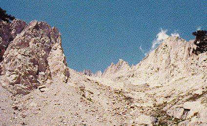
When you get to Trail Crest, there's nothing left to block the wind, and you're at 13,777 feet, so it's very cold. Unfortunately, Dave didn't account for this when dressing for the hike, so all he had was shorts and a t-shirt. Needless to say, he froze his ass off basically the whole time we were on the top. We took a brief rest to eat some beef jerky and drink some water and then continued on. The hike along the ridge was somewhat less steep (Trail Crest is less than a thousand feet below Whitney, and you do that in 2 1/2 miles), but it's still harder than the earlier part of the hike since you get tired very quickly up that high. Most of the trail was still trail, but occasionally we had to boulder-hop for a ways. The views to the west (and occasionally the east) are spectacular up there.
 (64 KB JPG)
The view to the west from the ridge between Trail Crest
and Mount Whitney. The lake on the right is Guitar Lake.
By the time we got to Whitney, the headache had returned, now more severe than ever, and some of the ensuing nausea as well. The last half mile or so, it was very difficult to keep track of the trail, so we ended up boulder-hopping most of the last part of the journey.
 (58 KB JPG)
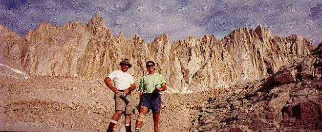
Dave and I at the top of Mount Whitney. Behind us are the
Sierras. To the far left of the picture is the summit hut.
The top was so crowded that we had to wait in line to sign the register. Many of the signers had written stuff like "We made it. Now let's puke." Some of the people were writing in times, presumably the time it had taken them from Whitney Portal to the top. The two people who signed the register right before me had hiked straight from Portal (without packs) in 5:40. One person on the same page had run the trail from Portal in 2:57!!! Hell, I was only half alive after having walked the last 4 miles in about that time.
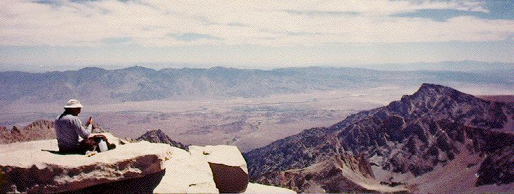 (61 KB JPG)
The view of the Owens Valley from the top of Mount Whitney.
We sat around on the peak for a while trying to catch our breath (good luck). Finally, I couldn't take the headache or the cold (30 degrees with wind chill) any more, so I snapped a couple of pictures (above) and we started to leave. Before we started out, I took a couple of swigs of water, which turned out to be a big mistake. Before you could say "reverse peristalsis," I was reverse-drinking that water and then violently dry heaving for a few minutes as well. When my diaphragm finally calmed down, we started down the hill, but this time more slowly. I really felt sorry for Dave, because I was pretty damn cold and he didn't even have the benefit of long sleeves.
After we descended the first major part, which is basically the backbone of Mount Whitney, I started feeling somewhat better. The nausea was gone and the headache was greatly reduced. The graudal downhill hike was a welcome relief from the more strenuous ascent. When we passed people going up, they were the out-of-breath ones and we smiled pleasantly and re-stated the obvious, "It's easier on the way down." We were moving a lot faster, and I didn't really tire until much later, when we were on the final descent from Trail Crest to Trail Camp.
We got back to our campsite at about 2:30, and Todd had some fruit cocktail ready, but we were both too tired to have any right away. We both ended up taking a siesta for about an hour, after which we had a massive dinner. We wanted to lighten up our packs as much as possible for the journey down the hill, so we prepared more food than we could eat. We knew that whatever we didn't finish, we could give to the marmots. This turned out to be the case, as we only ate about half of the green beans and a couple of spoonfuls of the raspberry cobbler. We left the rest out on a rock near our camp overnight. It was so cold at Trail Camp that after the sun went over the mountains it was pretty intolerable out. Thus, we all ended up going to bed early and waking up early.
We got up at about 5:30 and it was reasonably warm out, since the wind had died down. Todd went to check where we left the leftovers from dinner, and darned if the sugar-junkie little critters didn't eat the cobbler and leave the green beans. Marmots have no sense of nutrition. We had a leisurely breakfast and then packed up camp to head out.
Even though it's easier going down the mountains than it is going up, we knew that hiking out meant the end of our vacation, so there was a slight element of sadness to our descent. Even so, we tried to minimize stops, so that we could get off the mountain by lunchtime and thus miss some of the end-of-weekend traffic. We stopped briefly at a couple of places to rest or take a picture (see below), but didn't take our packs off all the way down.
 (75 KB JPG)
Dave and Todd at Trailside Meadows on our descent.
We tried to spark ourselves with the thought of a nice big greasy non-dehydrated cheeseburger that awaited us in Lone Pine. Our rigorous pace exacerbated the pain in Todd's knees towards the end of the hike, so we stopped several times to give him a rest, but we still made it back to the car by about 12:30. The last part of the hike was highlighted by several hang-gliders who must have launched from somewhere to our north at about 12,000 feet. They were catching good updrafts (thermals?), so they didn't descend, but just seemed to hover and circle like giant, brightly colored hawks surveying the sun-drenched Owens Valley below.
When we got to the car, we all just took off our packs, sat down, and took off our shoes. That act alone was bliss. Of course, we eventually had to get back up and pack up the car to go. Back in Lone Pine (now a brisk 95 degrees) we couldn't find any of the regular fast food places, but there was a place called the Frosty Chalet, so we stopped there. At the window, we were confronted by the frostiest wench who ever slung a burger. She couldn't win miss congeniality at a Manson party. The burgers were pretty good though, so after stopping for gas (for the car), we were headed back to the smog and traffic of Los Angeles.